Words from Wik

Sharing my Experiences

Friday, January 2, 2009

Aconcagua – Climbing Itinerary

So as I hinted at in my last blog post, I will head down to Argentina to climb Aconcagua. I leave tomorrow morning, and hopefully will be back in one piece at the end of the month. In case you want to know what I will be up to, you can check out this link (look for “Aconcagua January 2009”, should be a link once our trip starts in a few days), which should lead you to any updates we manage to send out about our trip. Also, I am posting below the proposed itinerary so that you get an idea for what it takes to get up and down this thing. See you all back in Feb!

Update: We successfully made it to the top and back! Will post more info later!

Jan 5: Arrive in Mendoza. Our staff will meet you at the airport and transport you to your hotel;

Jan 6: Sort Gear and visit the Permit Office in Mendoza, private transport to Pentitentes (2720 metres/8,900 feet) sleep in hotel;

Jan 7: Drive to Punta de Vacas. Walk 8 kilometers/5 miles, to Las Lenas (2,700 metres/8,800 feet). Easy trail walking; mules carry baggage. Camping;

Jan 8: Walk 18 kilometers/11 miles, to Casa de Piedra (3,200 metres/10,500 feet). Easy trail walking; mules carry baggage. Camping;

Jan 9: Walk 15 kilometers/9 miles, to basecamp, “Plaza Argentina” (4,200 metres/13,800 feet). Trail walking; mules carry baggage. Camping;

Jan 10: Rest in basecamp;

Jan 11: Carry loads for acclimatization safety to Camp 1 (5,000 metres/16,400 feet). Walking on scree and through melted ice mixed with rocks. 4-6 hour hike. Return to basecamp;

Jan 12: Rest day in basecamp;

Jan 13: Return to Camp 1, spend the night there;

Jan 14: Carry loads for acclimatization safety to Camp 2 (5,900 metres/19,400 feet). Walking on scree and through melted ice mixed with rocks. 6-7 hour hike. Return to Camp;

Jan 15: Return to Camp 2, spend the night there;

Jan 16: Rest in Camp 2; prepare for summit attempt;

Jan 17: Climb Traverse to connect with normal route at Independencia to Summit (6,962 metres/22,835 feet). Descend via upper Normal Route and traverse back to our Camp 2;

Jan 18, 19, 20: Extra days for further summit attempts, weather, and additional acclimatization;

Jan 21: Descend to Plaza Argentina;

Jan 22: Descend to Las Lenas camp, walking 33 km;

Jan 23: Return to Mendoza in transport and have celebration dinner, stay in hotel.

Jan 24: Depart Mendoza and head home.

posted by Wiktor at 22:18  

Friday, January 2, 2009

An email and a Favour

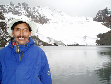
As some of you may know and have read on this blog, earlier this year I went to climb a 6000m mountain in Bolivia’s Cordillera Real. The trip was organized by two gentlemen, one a Bolivian named Iván Berdeja, and one a German named Christian. I have been keeping in touch with Iván, as he’s got lots of climbing experience, and with the latest email I sent about going to attempt Aconcagua, I got this reply:

Dear Wiktor,

I have very bad news. Our friend Iván died on Oct. 17 at the Cordillera Quimsa Cruz during a hike with a group of Italians. There was a lot of fog and he went forward in search of a path (there is a part with no path), he slipped and fell 250m. I can not describe to you the sadness we feel here. Ivan was a very, very good person.

I very much regret having to write that. At the same time I wish you a good expedition to Aconcagua. Please, will you leave a note in memory of Ivan at the summit?

Luck and greetings,
Christian

So I’ll say that this was totally unexpected, and I don’t really want to write any more commentary about it. I will let the letter speak for itself. However, what I will do is take a picture of Iván to the top of Aconcagua and leave it there (if I make it up). May he rest in peace.

Ivan Berdeja

posted by Wiktor at 21:58  

Saturday, June 21, 2008

Hiking in Samaipata, Bolivia

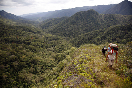
For my first real trip out and about in Bolivia, another BG new grad and myself went on a two day hike in a town a couple hours away from where we live. The area is higher in elevation and provides a slightly cooler climate, which was a good break from the heat and humidity we usually have in Santa Cruz. It’s also more mountainous and jungle-like than the city.

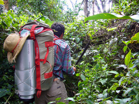
No trail most of the way, our guide had to cut a trail through the jungle.

The hike was through some very dense forest, and our guide Erwin had to use his machete often to cut a (very narrow and small) path for all of us. It was some tough hiking though, and being tall did not help me, at some points I had to go on all fours (with my backpack on) to get through the dense greenery! There was so much pathless jungle to navigate through that by the end of the hike our guide could not raise his machete hand to even point things out to us!

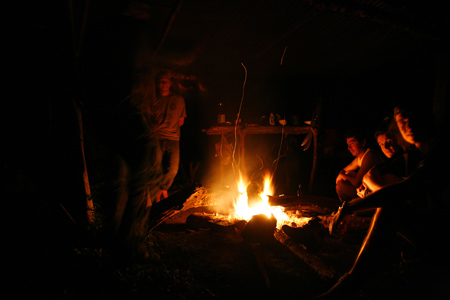
Campfire at Night

We had a nice campfire on the night we spent in the jungle, and met some other Italian hikers there who were doing a similar route, though we never actually saw them while hiking! Other highlights included looking at Puma and Jaguar tracks on the ground, though we never spotted the animals themselves! (Click on any of the pictures to go to the gallery and see more).

A nice view of the hills we climbed

All in all it was a nice trip, all the more so because it was my first getaway in Bolivia after all the time I spent working in the field. It was also a bit of training for me as I plan on climbing some mountains in Bolivia’s Andes, which I will be doing in the next few weeks, so stay tuned for some pictures and stories from that!

posted by Wiktor at 11:34  

Thursday, June 28, 2007

Kebnekaise – 2111m

Executive Summary: Since this is a long post I will give you the quick and dirty here for those who don’t want to read it all (though I do recommend it obviously!) Skip it if you want the suspenseful version! Once again bit off more than I can chew hiking. Walked about 60 km in 48 hours: 20km hike to base camp (after a horrible night’s sleep on train), sleep with the sun in eyes all night, take 5.5 hours to ascend 1850m to summit, take another 5.5 hours to come back, sleep with sun in eyes again, hike 20km home. This was done before the mountain was officially opened and there was still too much snow, so summiting was done half with snowshoes. I wasn’t sure if the effort was worth it after doing it all, but after a few days I got over it and was glad I did it. Rest of Sweden was wonderful, people are great and the weather worked out, definitely a place I recommend visiting in the summer. See pictures below (click on them for more pics)!

End Executive Summary

After I scaled the UK’s tallest peak (see previous post), I thought to myself, “Why not scale the tallest peaks in other countries as well? I am after all from Canada, have done a bunch of hiking there, and we got some big mountains. So these should be no problem!”

With that attitude I went to Sweden and first thing I did on my 10-day stay was to go to Kiruna (where the sun always shines during this time of year, home to the Ice Hotel in the winter). From there it’s possible to summit Sweden’s tallest peak, Kebnekaise, at 2111m (if you count the glacier that sits on top of the rocky peak). I took nothing lightly though, the base mountain station is at 670m or so elevation, so a good 1400m climb is involved, which is no picnic (but it’s only a little more elevation gain than I had done on UK’s tallest mountain, that took 2h20m).

I was however unprepared for some other things. I had read about the fact that the mountain station can only be reached by hiking (think of it as a sort of base camp), but I had completely forgot. Another thing is that on arriving and asking how I can get to the mountain, they told me it doesn’t open for two weeks so I can’t go up top. All this led to a whole bunch of confusion, and after straightening everything out I had to do the following:

I had about one hour to go buy all my food for the next three days, knowing I will have to carry it all on my back for 20km to the mountain station. Take too little and go hungry, take too much and my shoulders would cry.

Catch the last bus of the week (no buses for next two days) to village, hike 20km with food on back to the mountain station. I had to hurry to make it to bed at a reasonable time, and the fact that the previous night I had spent drinking beer with the locals and sleeping only 5 hours on a night train didn’t help.

Finally I arrived at the mountain station, my home for the next two nights, glad to have all the confusion behind me. At the station I found some nice German guys who had attempted the summit that day. They were walking around stiff-legged and in some discomfort, and they told me they had spent 12 hours (round trip) making an unsuccessful attempt at the summit. They had to turn back because the snow was waist-deep, and they had big heavy backpacks that made them sink very easily. They were climbing the mountain alpine style so that they could camp on the other side after summiting, and all that weight and no snow shoes kept them from the top. Luckily I managed to track down some of the people that were preparing the mountain station for opening and got them to rent me snowshoes from their shop, hoping to make it myself.

That night was my first night sleeping in a place where the sun shines 24 hours. I must say it totally messes with your internal clock. The day just flies by, and the night is tough unless the room has no windows. It was not the best sleep I had by a long shot.

Next day I set out to summit while the German guys were taking a day of rest. I told myself I would do like them and turn back if I didn’t get up the mountain in 6 hours. Actually I was hoping to make it in 5 or less, but after 5 hours I still had a ways to go so I just kept pushing. It was the most exhausting hike ever. About half of the elevation gain had to be covered in snowshoes as there was still a lot of snow on the mountain. This was the toughest part, as going up in snowshoes means every step you take you sink, then when pulling your back foot out of the snow your front foot sinks even more. Place back foot in front, sink. Wash, rinse, repeat. Just taking step after step was difficult. I thought of stories I had heard about people climbing Everest, how every step is a huge mental effort, and I felt much the same way (though obviously I had nothing on Everest). I eventually made it to the top in 5h30m, ready to die.

The GPS I had said I had ascended 1850m and descended 360m on my way up. That’s a lot more than the 1400m I was expecting, because the way there actually goes up and down over a slightly smaller peak. That also means that the 360m I descended I have to climb back up on the way home. All those numbers add up to a very long day and a very tired Wiktor. Anyways, after spending about 30 minutes on the peak taking panoramic photos, I went back with no significant events, other than the usual tiredness of snowshoeing up the smaller peak. I think my trip was just shy of 12 hours (luckily the sun shines all the time so there’s no chance of being left in the dark!) Back at the mountain station I had a dinner that seemed very small compared to my appetite after that climb (I guess I erred on the side of going hungry in choosing how much food to bring).

After another bad night of sleeping with daylight in my eyes, I hiked the 20km back to town with the German guys. It was good to hear some of their other stories they had about climbing in the alps, and I felt a little bad for them because they certainly came well prepared and knew what they were doing, had crampons ready for ice, but just couldn’t get past the deep snow.

For some more commentary and pictures click on any of the pictures above. And to make a long story even longer, the rest of the trip in Sweden was great. The country is probably the most similar to Canada of all the European countries. The people are really nice, I met a few and stayed at one of their houses for a night. Stockholm is a great city, parts of it remind me of Zurich (which is a good thing!) and a great place to party all night when the sun barely sets for a couple hours, and dawn comes well before people consider calling it a night (and that was on a Tuesday).

That’s about all there is to write for this trip, now I’m spending my time in rainy Aberdeen. I feel like I’m living a two-part life, one very different from the other, completely unrelated and uncoupled.
posted by Wiktor at 10:58  

Wednesday, June 6, 2007

Ben Nevis – 1344m

A quick post about what I was up to a couple weeks back: hiking up the tallest mountain in the UK, Ben Nevis. While the size of the mountain may make it seem like not much of an achievement (1344m), the start is at about sea level, so it’s a decent climb. That, and I bit off a little more than I could chew by deciding to climb it with another Canadian I met in the hostel; he is a park ranger manager in BC and climbs mountains for a living. So, for the first bit I could keep his pace, but eventually I had to tell him to slow it down a little or leave me behind! He has kids my age, yet I felt like the old man and developed a hip problem going up. But by having his pace to keep up to, I think I set a personal best for getting my ass up a mountain!

Unfortunately, there wasn’t much to see from the top; the peak is clouded over about 70% of days. It also rains over 7 times as much there as it does in ‘sunny’ London. The picture at the bottom shows us two Canadians on the top with snow on the ground and cloud all around (click here for more pictures).

Next on the list for me: go to Sweden and climb their tallest mountain. For some reason that’s what I feel like doing, climbing mountains, rather than just going to a place to say I’ve been there. That and of course partying it up with local Swedish girls!

Ben Nevis - 1344m and cloudy

posted by Wiktor at 11:31  
« Previous Page

Powered by WordPress