North vs. South
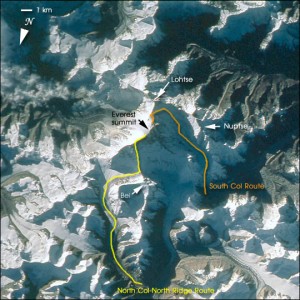
I will be attempting to climb Mt. Everest via the southern col route, or southeast ridge route, which is in the country of Nepal. The other main route is the northeast col route, via the northeast ridge, which lies in Tibet (or China). You’ll generally hear people talk about them as either the North route and Chinese side, or South route and Nepali side. There are of course other ways up the mountain, you can go up whichever way you like, but if you’re not going up either of these two routes it’s because you want more of a challenge.
The first step in climbing Everest is deciding you want to go. The second step is deciding which route you want to take. I just thought I would go over some of the pros and cons of each side, and why I chose the side I did. Know that this is based on what I have heard and read (and I have asked a lot of questions about this of our leader Arnold, who has climbed on both sides), but obviously I haven’t yet been on either route.
Getting to the base camp on the North side means driving in. A while back when the Chinese were trying to put some of their own people to the top they made a road that goes all the way into base camp, and then paved it to put the Olympic torch onto the summit. Getting to base camp on the south means hiking in through the Khumbu Valley, which is supposed to be a very beautiful hike in, and worth the trip by itself just to hike into base camp. This takes about 10 days because of the need to stop and take rest days to acclimatize to the altitude. The Nepalis have made a national park of this area so roads are not going to be constructed anytime soon.
The North side is generally considered colder, as it sees less sun, whereas the South side can get decently warm when the sun is out. It’s a major consideration for some, especially those more susceptible to getting cold in their extremities.
The route itself is considered easier on the North side up to camp 4, where you sleep before summit day, but above camp 4 there are three technical sections (known by their imaginative names as the First, Second, and Third Steps) that catch a lot of people unprepared. This then creates the opportunity for people with limited technical competence to get quite high, then have trouble on the toughest sections, on the toughest day, and create traffic jams for everyone else. On the South the route apparently gets a bit more involved early on, and while it also has it’s technical section on summit day called the Hillary Step that can cause traffic jams, if you’ve gotten there already you have a decent chance of making it over without causing too many problems for others.
Then there’s the location of Camp 4, the highest camp before the summit. On the North side it’s at 8300m, which is the highest camp on earth! This means you have to spend a night at this altitude before trying for the summit. On the south side the camp is a little lower at 8000m, where you still need to sleep on oxygen, but it’s that much lower. However, that also means that you have 850m to climb to the summit from the South, and only 550m from the North; therefore summit day takes significantly longer from the South, but as stated above it is technically not as involved.
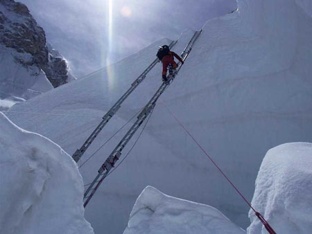
Another consideration is the famed Khumbu Ice Fall on the South, where you have to cross large bottomless crevasses via ladders strapped together end to end. It is the most dangerous part of the ascent via either side, and it’s for this reason alone that some people choose to climb from the North. The problem is that the ice fall is continuously moving, and while navigating through it there are chances that pieces will break off, onto people or break ladders that people are on. To me it’s the kind of risk you can do almost nothing about (other than avoid it by going the North route), as it becomes a lottery for who might or might not be affected.
One last difference is price. The Northern route is generally cheaper. This is because of logistics and getting people and supplies to base camp is done all by car. On the South, people and supplies are first flown from Kathmandu to Lukla, then people hike and supplies are taken by Yak to base camp. All this takes time and money. There might be a slight difference in permit price too, but I am not exactly sure.
So why did I choose the South side? Several reasons. I have heard such good things about the hike to base camp through the Khumbu Valley that I wanted to experience that myself. Getting to base camp from the North involves a drive that I have already done, as it’s almost the exact same approach as getting to Cho Oyu base camp. Another reason is that I would like if the people that are climbing around me on summit day have earned their place, and are not going to be caught off guard by the technical sections and cause traffic jams.
But the main reason is a difference that I only slightly touched on above, and that’s the attitude of the countries in which these two approaches lie. China made a road. Nepal made a national park. China has been known to limit access across the border when things in Tibet start heating up. If I can help it I will put my money into the country that is doing things the way I support, and not politically oppressing the region I am climbing in. But that’s a whole other story that I won’t get into.
So, what side would you choose? 🙂

